Geophysical & Geotechnical Services
The Overdue Great Earthquake of the Central Himalayas
September 28, 2026

Seismic Vulnerability of the Central Himalayan Region of India and the Case for an M ≥ 8 Event and What Can Be Done About It
Executive Summary
The Himalaya is the seismic expression of a continent-scale collision. The Indian plate continues to underthrust the Eurasian plate at roughly 50 mm per year, and the resulting crustal shortening is stored as elastic strain along the Himalayan plate boundary. That strain is released episodically as large (M ≥ 7) and great (M ≥ 8) earthquakes. Between 1897 and 1950 the arc was struck by four great earthquakes: 1897 Shillong (Assam), 1905 Kangra, 1934 Nepal-Bihar (M 8.4) and 1950 Assam. Since 1950, and in some segments for far longer, the largest ruptures have not recurred, even as strain has kept accumulating.
The seismological literature's central conclusion is direct: the Central Himalaya is overdue for a great earthquake of magnitude 8 or above. Khattri (1987) identified the segment between the 1905 Kangra and 1934 Nepal–Bihar rupture zones, the “Central Seismic Gap”, as a zone in which no great earthquake (M ≥ 8) has occurred for at least 200 years. Bilham et al. (2001) estimated the slip accumulated by steady plate motion and concluded that great Himalayan earthquakes are overdue even after accounting for aseismic creep. A large fraction of this gap lies within Uttarakhand, India, and the adjacent Nepal border, directly threatening the densely populated Ganga plain.
The consequences of releasing this stored strain would be severe. Wyss (2005) estimated that a single great Himalayan earthquake could kill as many as 150,000 people, injure 300,000, and affect roughly 3,000 settlements. Modern risk, vulnerability and coping-capacity mapping of the region confirms that the highest-hazard belt coincides with high population exposure and limited local coping capacity, the combination that turns a hazard into a disaster.
Because the precise timing of an individual earthquake is not predictable, risk reduction is the only reliable defence. This report therefore closes on the mitigation response now operating in the Indian Central Himalaya, centred on the Uttarakhand State Earthquake Early Warning System (UEEWS) and its public-facing BhuDEV app, developed by IIT Roorkee with the Government of Uttarakhand / USDMA, alongside the structural and preparedness measures that determine whether the next great earthquake becomes a catastrophe or a survivable event.
At a glance


1. The Himalaya: A Collision Boundary Under Load
According to plate-tectonic theory the Earth's rigid outer shell is divided into a mosaic of major and minor plates in constant relative motion. Large earthquakes cluster at plate margins, where strain energy accumulated over decades to centuries is released suddenly. The Himalaya sits on one of the most active of these margins: the boundary between the northward-moving Indian plate and the Eurasian plate.
The collision began roughly 55 million years ago with the closure of the ancient Tethys Ocean, and it has not stopped. The Indian plate continues to push northward at an average rate of about 50 mm per year. This convergence is absorbed not only in building the Himalaya and the Tibetan Plateau but across a wide zone of deformation extending north of Tibet. The Himalayan arc itself forms a well-defined curve of about 2,500 km, running from Nanga Parbat (8,215 m) in the west-northwest to Namcha Barwa (7,755 m) in the east-northeast.
Crucially, most of this convergence is not accommodated by smooth, continuous slip. The great Himalayan thrusts are, in Richter's phrase, largely quiescent for great earthquakes between events , they lock, load elastic strain, and then fail. The Main Boundary Thrust (MBT) and associated thrust faults mark the surface expression of the Indian plate underthrusting beneath Tibet, and it is along these structures that the region's largest earthquakes nucleate.
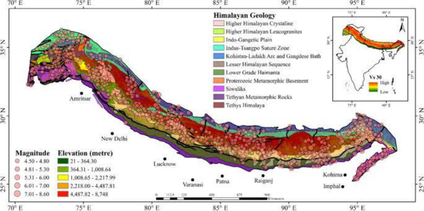
Figure 1. Geology and historical seismicity of the Himalayan arc. Circles show earthquake epicentres scaled by magnitude (4.5–8.6) over the geological provinces of the range; the belt of large events tracks the plate boundary from the northwest Himalaya through Nepal to the northeast. New Delhi and other exposed population centres lie immediately south of the seismogenic front.
Why this matters
A convergence rate of ~50 mm/yr means that every century the plate boundary must absorb several metres of relative motion. If a segment has not ruptured in a great earthquake for ~200 years, several metres of slip deficit have accumulated there.
2. Stress Accumulation and the Slip-Deficit Argument
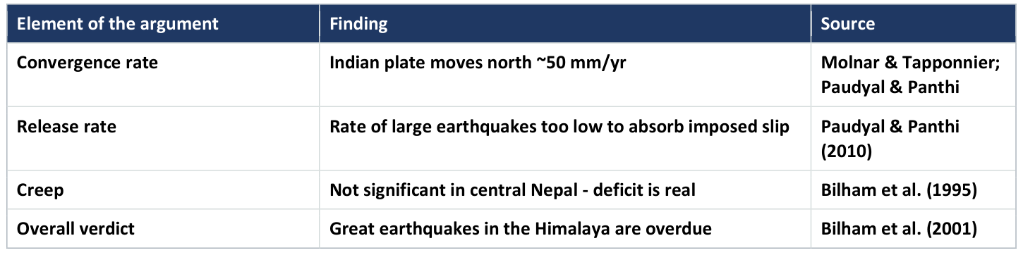
The physical case for an overdue great earthquake rests on a simple balance. Plate motion adds slip deficit to a locked fault at a steady rate; and earthquakes remove it. If the long-term rate of great earthquakes is too low to release the slip imposed by plate motion, the deficit must be building toward a future large rupture, unless it is being quietly released by aseismic creep.
The current seismicity pattern shows that the rate of occurrence of large earthquakes is evidently too low to accommodate the full Indo-Tibetan slip. That slip must therefore be taken up either by creep or by occasional great earthquakes. Direct measurement in central Nepal (Bilham et al., 1995) found that creep is not significant there; meaning the deficit is genuine and is destined to be released seismically.
Building on this, Bilham, Gaur and Molnar (2001) estimated the potential slip accumulated by constant plate motion along the arc and concluded that large Himalayan earthquakes are overdue, even if a substantial fraction of plate motion is absorbed by creep. This is the analytical core of the report's thesis: the Central Himalaya is not merely capable of a great earthquake; it is carrying a slip deficit consistent with one.
3. The Four Great Earthquakes of 1897–1950
Within a span of just 55 years the Himalayan belt was rocked by four great earthquakes, together with a large number of strong events that caused enormous loss of life and property. These four define the modern reference frame for Himalayan seismic hazard because their rupture zones divide the arc and reveal the gaps between them.
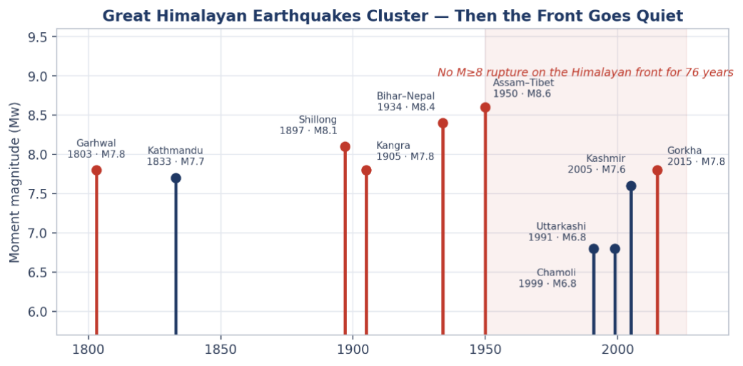
Large and great Himalayan earthquakes, 1803–2026. The arc released four great earthquakes in fifty-five years and none on the frontal thrust since 1950. Moderate events since 1991 have not relieved the accumulated deficit.
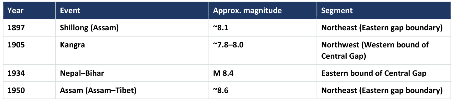
The 1934 Nepal–Bihar earthquake (M 8.4) alone stands as one of the defining catastrophes of the region and marks the eastern edge of the segment of greatest present concern. The distribution of these rupture zones along the arc is not continuous: between them lie stretches that did not rupture in 1897–1950 and, in the central case, have not ruptured in a great earthquake within the historical record.
4. The Central Seismic Gap
The concept of a seismic gap is straightforward: a segment of an active plate boundary that has not produced a large earthquake for an unusually long time, while its neighbours have, is a prime candidate for the next one because it is still accumulating the strain its neighbours already released.
Khattri (1987), using seismicity data from 1800 to 1982, identified the segment between the rupture zones of the 1905 Kangra and 1934 Nepal–Bihar earthquakes as the Central Gap, in which no great earthquake (M ≥ 8) has occurred for at least the last 200 years. He concluded that this region is a potential site for future great seismic activity. A comparable Eastern Gap lies between the 1897 Shillong and 1950 Assam ruptures.
The seismological significance is compounded by the energy record. Analysis of annual seismic energy release for 1963–2006 shows a gradual increase toward the northwest and north-northeast of the 1934 epicentre, leaving a conspicuous low-release area over the western Nepal region (Paudyal & Singh, 2008). Low recent energy release in a segment known to be loading is exactly the signature of a locked, strain-accumulating gap. Bilham et al. (2001) accordingly assessed a very high probability of a mega-event in these gaps in the near future.
A major portion of the central seismic gap lies within the territory of Nepal and the adjoining Indian Himalaya of Uttarakhand, placing the states of the Indian Central Himalaya and the population of the Ganga plain squarely in the shadow of the most likely future great earthquake.
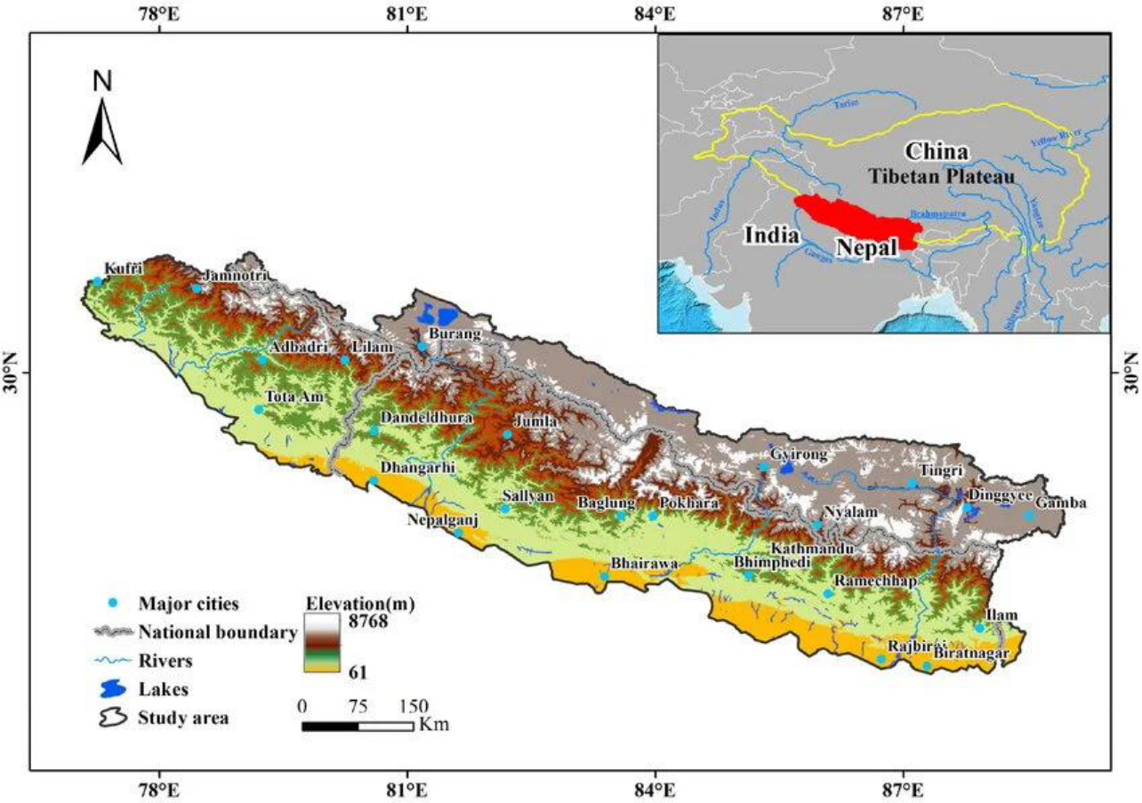
Figure 2. Study-area setting of the Central Himalaya astride the India–Nepal border, spanning the Uttarakhand Himalaya and western Nepal. Elevation rises sharply from the Ganga plain (~61 m) to over 8,700 m, concentrating exposed population in the foothill and plain districts immediately downslope of the seismogenic front.
5. The Seismic History of the Central Himalaya
The Central Himalaya has been the site of repeated large earthquakes. Historical accounts record major, probably seismic, destruction of the Kathmandu region in 1223, 1255, 1344, 1408, 1681 and 1833, with further major events within Nepal in 1916, 1934 and 1936. Eight large earthquakes of M ≥ 7 struck the Central Himalayan region between 1803 and 1936, including the 1934 great earthquake.
The temporal pattern of these events is not random but clusters into alternating active and quiet phases, a high–low–high–low rhythm from 1803 to 2006:
First high-activity phase, continued for 37 years (1833–1869), producing four M ≥ 7 earthquakes.
First quiescence: ~46 years of extremely low seismic activity.
Second high-activity phase, a shorter, intense 21-year burst (1916–1936) producing three large earthquakes including the 1934 M 8.4 event; about 30 events of M 6–6.9 also occurred through 1966.
Current low-seismicity phase: evident since 1967, over ~42 years only eight earthquakes of M 6–6.6 occurred, with no great earthquake at all.
This present quiet is not reassuring. In a boundary that must absorb ~50 mm/yr, a prolonged interval with no great rupture means loading without release. Most of these large earthquakes are associated with the Main Boundary Thrust in a thrust-faulting environment, signifying the ongoing subduction of the Indian plate beneath the Tibetan plate, the same mechanism that will drive the next great event.
6. Risk, Vulnerability and Coping Capacity
Hazard is only one term in the disaster equation. A great earthquake becomes a catastrophe when high hazard overlaps high exposure (people and assets in harm's way), high vulnerability (weak buildings, poor preparedness) and low coping capacity (limited ability to respond and recover). Integrated mapping of the Himalaya shows precisely this dangerous overlap across the central arc.
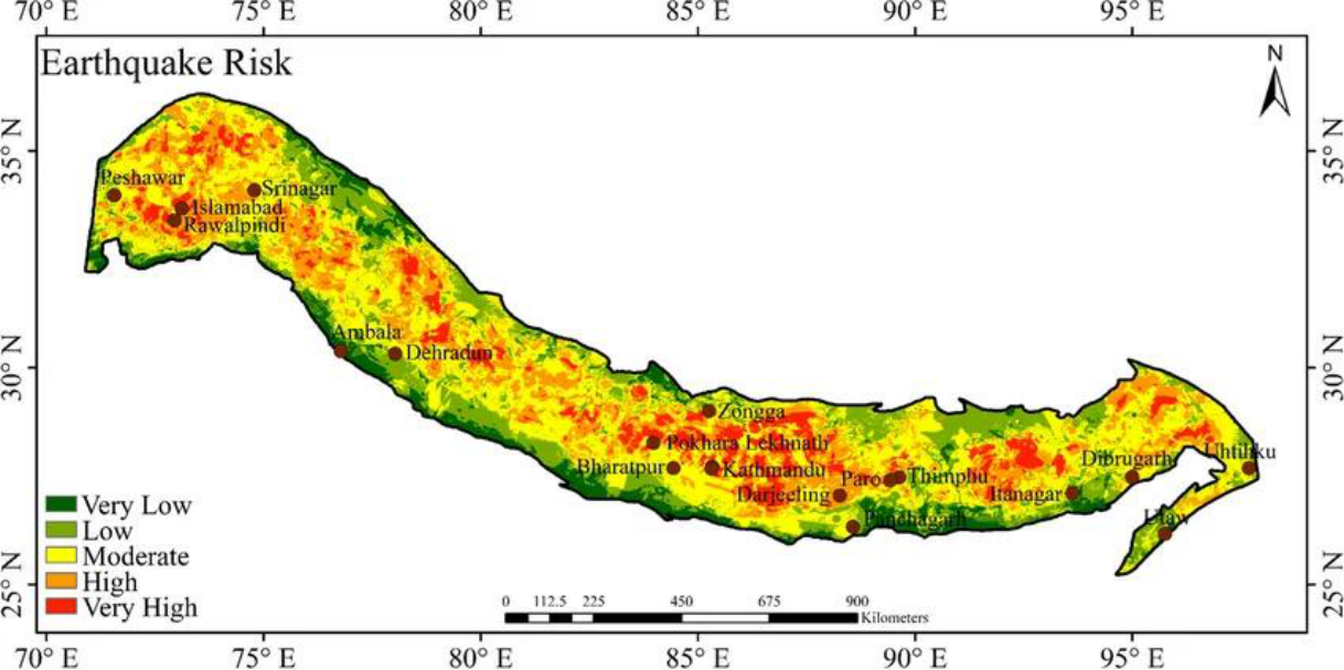
Figure 3. Integrated earthquake-risk map of the Himalayan region. Orange and red zones (High / Very high) concentrate along the central and northwestern arc, including the Uttarakhand and West-Nepal segments that make up the Central Seismic Gap, where high hazard overlaps dense settlement.
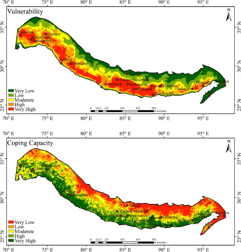
Figure 4. Vulnerability (top) and coping capacity (bottom) across the Himalayan arc. Large stretches of the central and northwestern belt combine High / Very-high vulnerability with Very-low to Low coping capacity, which is the worst possible pairing for the segment already carrying the greatest seismic-gap hazard.
The pattern is unambiguous. Where vulnerability is highest, coping capacity is frequently lowest, and both coincide with the high-hazard central and northwestern arc.
Rapid, often unregulated urbanisation across the foothill towns and the Ganga plain adds exposed population and non-engineered construction faster than resilience can be built, steadily raising the human cost of the earthquake that the gap analysis says is coming.
How urbanisation converts a tectonic hazard into a mass-casualty event
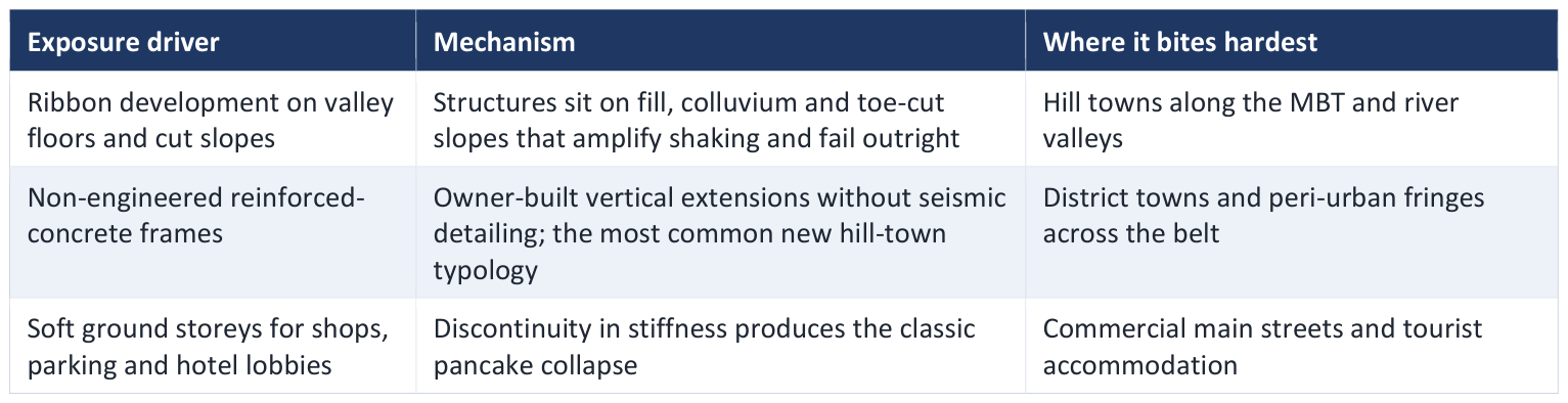
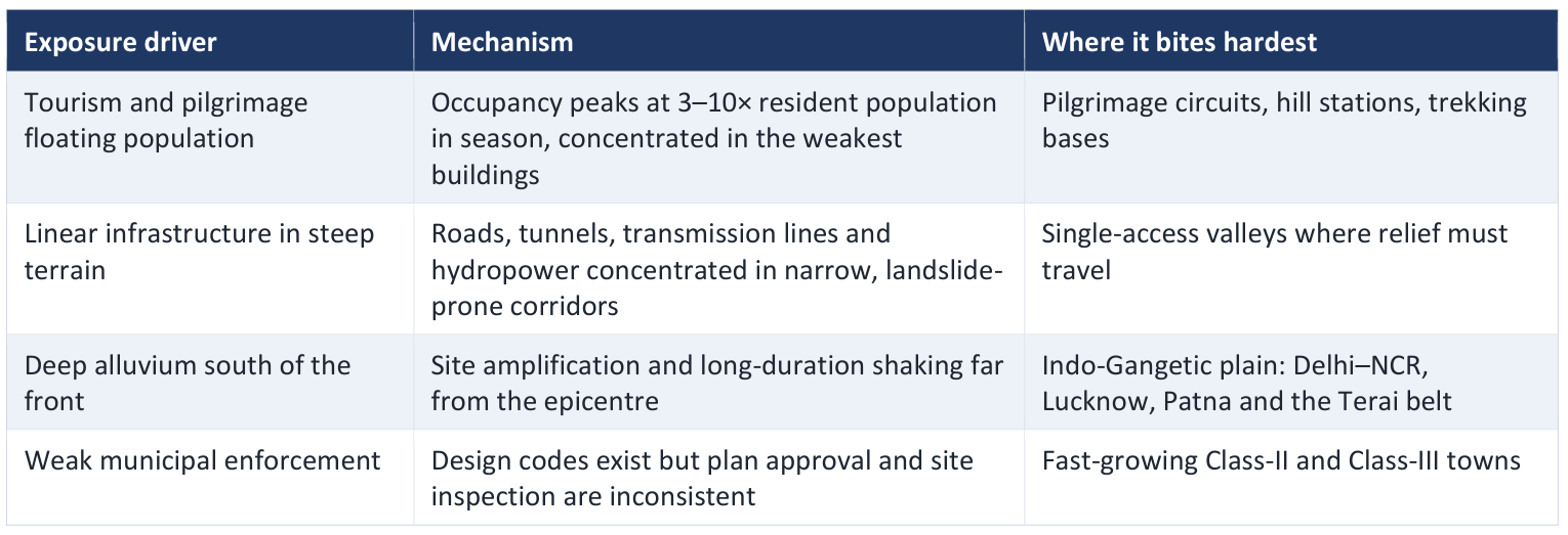
The ground-condition dimension deserves separate emphasis. Slope instability in the Himalaya is not only a co-seismic consequence; in several hill towns it is already visible aseismically, in the form of progressive subsidence and structural distress caused by slope loading, drainage failure and excavation. Settlements that are deforming under static loading today will not behave well under several tens of seconds of strong shaking.
The disaster equation
Risk = Hazard × Exposure × Vulnerability ÷ Coping Capacity. The Central Himalaya scores adversely on every term: a loaded seismic gap (hazard), a densely settled plain (exposure), weak building stock (vulnerability), and limited local response capacity (coping).
7. The Human and Economic Stakes
Quantitative loss estimates translate the seismological argument into human terms. Considering probable ruptures of 150 km segments at seven positions along the Himalayan plate boundary- Kashmir, Dehra Dun, Garhwal, West Nepal, Kathmandu, Bhutan and Assam- where sufficient elastic energy is believed to be stored for magnitude-8 earthquakes, Wyss (2005) estimated the potential losses from a single future great event.
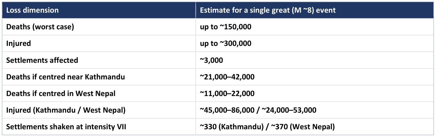
These are scientific scenario estimates, not forecasts of a specific date, and they exclude cascading hazards. Because Upreti (2006) records that the most common natural disasters in the region already include landslides, debris flows, floods, glacial-lake outburst floods, and avalanches, a great earthquake in this steep, saturated terrain would trigger secondary disasters- co-seismic landslides damming rivers, outburst floods and prolonged loss of road access- that can rival the direct shaking losses. Nepal ranks eleventh globally in relative vulnerability to earthquakes, and the exposed Indian foothill and plain districts share the same underlying risk.
8. Why We Cannot Predict the Date and What Follows
A valid earthquake prediction, in the classical framing (Allen, 1976), must specify four elements: location, size, occurrence time, and probability, each with its uncertainty. Current understanding of seismic dynamics can constrain the location, the plausible size, and the probability of a Central Himalayan great earthquake reasonably well. It cannot constrain the third element. The scientific consensus is that the precise timing of an individual earthquake is inherently unpredictable.
This is the pivot of the whole report. If the location and size are effectively known but the date is not, then waiting for a prediction is not a strategy. The only rational response is to reduce the consequences in advance through early warning that buys seconds before the damaging waves arrive, resilient construction that keeps buildings standing, and preparedness that keeps people alive and able to respond.
9. The Regulatory Gap: The 2025 Seismic Code and Its Rollback
The Bureau of Indian Standards notified a revised earthquake design code, IS 1893:2025, built on probabilistic seismic hazard assessment, active fault mapping and near-fault effects. The revision introduced a new Zone VI for extremely high seismic hazard and placed the entire Himalayan arc, from Jammu and Kashmir to Arunachal Pradesh, within it, alongside parts of the Indo-Gangetic plain including Delhi and Guwahati; roughly 61% of the land area would have fallen in moderate-to-high hazard zones. The code was withdrawn in March 2026 after the Ministry of Housing and Urban Affairs raised objections on construction cost, an estimated 10–15% increase for buildings in the highest zones and up to 50% for major infrastructure projects and on inadequate consultation with states and industry. IS 1893 (Part 1):2016, with its four-zone map, is once again the applicable standard.
Whatever view one takes of the cost objection, the practical consequence for risk management is unambiguous. The hazard did not change in March 2026; only the design basis did. Structures being permitted in Himalayan towns this year are being designed to Zone IV and V forces, on a map that the country's own technical revision concluded understates the hazard along the arc. Because building stock turns over across decades, this decision is effectively locked in for a generation of construction.
Policy implication
A withdrawn code creates a mitigation gap that cannot be closed by structural means inside the next decade. The rational response is not to relitigate the code in this brief, but to (i) restart the revision with a staged, consulted, cost- phased pathway and a published timetable; (ii) apply the higher design basis immediately and by administrative order to new public buildings, schools, hospitals, lifeline infrastructure and state-funded projects in the arc, where the cost increase is absorbable and the occupancy is public; and (iii) accelerate the one instrument whose benefit does not depend on the building stock at all — early warning.
10. Earthquake Early Warning: The Core Idea
Earthquake Early Warning (EEW) exploits a simple physical fact: the fast, low-damage P-wave outruns the slower, destructive S-wave and surface waves. By detecting the P-wave near the source and estimating the event, an automated system can send a warning ahead of the strong shaking, buying anywhere from a few seconds to tens of seconds at the target site. In those seconds, gas lines can close, trains slow, surgeries pause, and people move away from hazards.
Two design approaches
Regional (front-detection) approach: A dense network of seismic stations feeds a central processing unit that estimates the earthquake's location, magnitude and expected ground-motion intensity at the target site. It is most useful when the source is some distance from the population centre, and it typically provides warning times of a few seconds to tens of seconds.
Onsite approach: A sensor at the target site analyses the initial portion of the P-wave and issues a warning at the same site, with no central processing unit. It is faster and useful where the source is close to the population, but it is less accurate and leaves a small “blind zone” around the epicentre where no useful warning is possible.
In the Himalaya both approaches matter, because major population centres in the foothills and plain (regional-approach territory) coexist with towns sitting almost on top of the seismogenic front (onsite territory). India's national effort reflects this: the National Centre for Seismology (NCS), under the Ministry of Earth Sciences (MoES), has been piloting an EEW system in the northwest Himalaya, and institutions such as IIT Roorkee have advanced dense sensor networks, real-time data processing and dissemination. The persistent challenges are response time, reliability of the disseminated alert, and reaching remote areas affordably in the absence of a nationwide system.
11. The Solution in Practice: Uttarakhand's EEW System and the BhuDEV App
The clearest operational answer in the Indian Central Himalaya is the Uttarakhand State Earthquake Early Warning System (UEEWS) and its public interface, the BhuDEV app. It converts the abstract early-warning concept into a working service for exactly the population identified above as most at risk.
The system
The Government of Uttarakhand, working with IIT Roorkee's Centre of Excellence in Disaster Mitigation and Management, launched the UEEWS to the public on 4 August 2021. The system is built on an array of about 170 accelerometers installed across the seismogenic areas of Uttarakhand. Ground-motion data stream from these sensors to a central server over a dedicated private telecommunication network, 24 hours a day, seven days a week. When the server anticipates an imminent earthquake of magnitude 5 or above originating in Uttarakhand, it issues warnings, through the mobile app and through siren units installed in government-earmarked buildings, before the damaging waves reach users' locations.
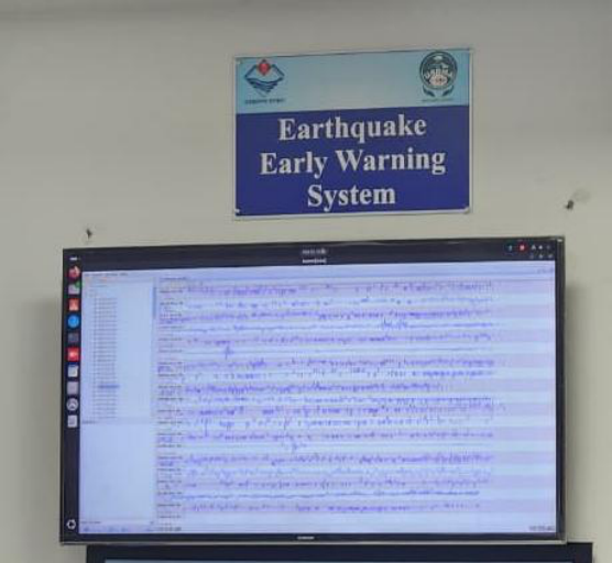
(Earthquake EWS monitoring & notification setup observed at State Disaster Management Authority, Uttarakhand)
The app: BhuDEV
BhuDEV (Bhukamp Disaster Early Vigilante) is the smartphone app that carries the warning to the public. Developed by IIT Roorkee with the Government of Uttarakhand (and disseminated through the state disaster-management machinery, USDMA), it is freely available on Android and iOS. Users register once, providing the essential location details the system needs to target alerts. Its core functions:
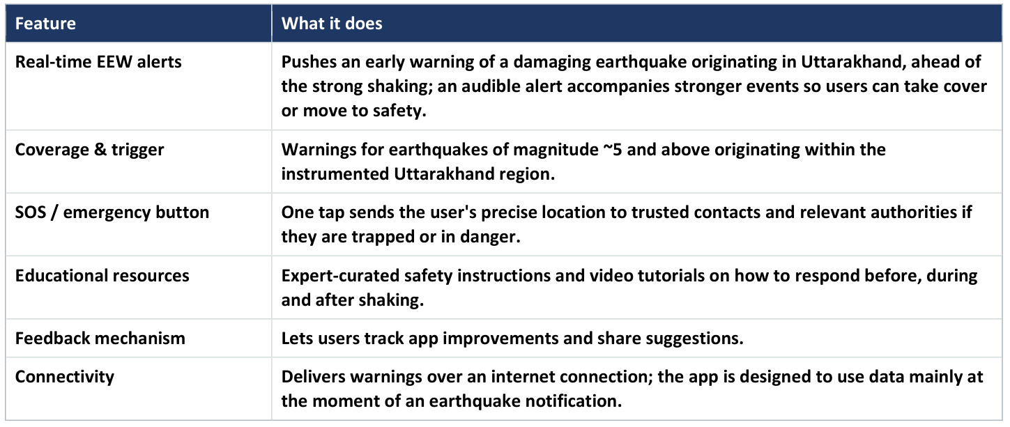
BhuDEV is not a prediction tool and does not claim to be. As an automated system it may occasionally miss an event or issue a false warning, and the operators state as much. Its value is probabilistic and time-critical: across many events it delivers the seconds of advance notice that let people and automated systems act. For a population living on top of a loaded seismic gap, those seconds are precisely what the seismology says cannot otherwise be bought and BhuDEV is the model that the rest of the Central Himalaya, including the West-Nepal and Garhwal segments of the gap, needs to extend and replicate.
Why BhuDEV fits the problem
The Central Gap threatens Uttarakhand's foothill and plain population with a source that is often close by. UEEWS pairs a regional sensor array (170 accelerometers) with onsite-style rapid dissemination via BhuDEV, matching the dual-approach need.
12. Recommendations: A Five-Pillar EEW Programme
The five pillars below are sequenced so that each is independently useful. A government that funds only the first two still ends up with a better system than it has; a government that funds all five ends up with an operational national capability inside five years.
PILLAR 1 DETECT: instrument the front to alerting specification
Build a front-parallel array along the Main Frontal and Main Boundary Thrust corridor with target station spacing of 20 km or less in Priority-1 segments and 30–40 km elsewhere, so that four or more stations register the P-wave within three seconds of origin.
Co-locate strong-motion accelerographs with broadband seismometers and high-rate GNSS. GNSS matters specifically because conventional magnitude estimators saturate above about M 7.5, the exact range this brief is concerned with and displacement-based estimates do not.
Use borehole or vault installations at high-noise urban sites, and densify inside Priority-1 towns with low-cost MEMS accelerometers in schools, hospitals and municipal buildings to support on-site alerting.
Specify dual-path telemetry (fibre where available, cellular and VSAT as fallback) with independent power, solar plus at least 72 hours of battery, because the network must survive the event it is reporting, and because aftershock warning is as operationally valuable as the mainshock alert.
PILLAR 2 DECIDE: hybrid algorithms and intensity-based thresholds
Operate regional and on-site algorithms in parallel: regional front-detection for the plains and distant cities, on-site P-wave alerting for towns inside the blind zone.
Require multi-station association (a minimum of four stations) before a public alert, to suppress single-sensor false triggers, while permitting on-site devices to actuate locally on a single trigger where the consequence of a false actuation is low.
Alert on predicted intensity at the recipient's location, not on magnitude alone. The public threshold should be expected MMI V or above; actuation thresholds should be set per asset class by the regulator for that sector.
Issue graded and updated alerts, and publish the update rule in advance so that operators design for revision rather than treating a downgrade as a failure.
PILLAR 3 DELIVER: make cell broadcast the primary channel
Mandate cell broadcast on all mobile networks as the primary EEW delivery channel, integrated with a CAP-compliant national alert aggregator. Cell broadcast is a one-to-many transmission: it does not queue, does not congest and does not require an app, a subscription or a data session.
Retain the app (BhuDEV and successors) as a supplementary and richer channel, not as the channel of record.
Deploy sirens with a distinct, nationally standardised earthquake tone in dense towns, schools, hospitals, transport hubs and pilgrimage sites, with public-address override at terminals.
Mandate automatic interruption on television and radio, and provide a machine-readable feed for industrial and institutional subscribers.
Standardise the alert grammar in Hindi, English and the principal regional languages, in a fixed word order, with an audio form for low-literacy and visually impaired recipients: hazard, action, time.
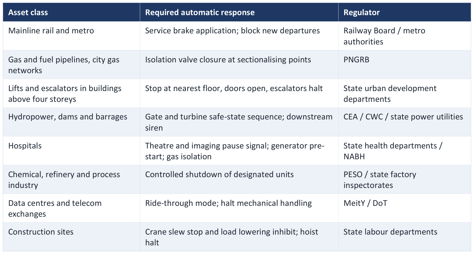
PILLAR 4 ACT: publish automatic-actuation standards
This is the pillar with the highest benefit-to-cost ratio and the one currently missing entirely. The Bureau of Indian Standards, with the sectoral regulators, should publish a standard for automatic seismic actuation specifying, for each asset class, the trigger threshold, the required response and the maximum permitted actuation latency.
PILLAR 5 DEMONSTRATE: measure, drill and audit in public
Publish system performance quarterly: detections, alerts issued, measured end-to-end latency distribution, false-alarm and missed-alarm counts, and delivery reach.
Run biannual drills in every school and public hospital in Zone IV and V districts, timed and scored, with alert-to-action time recorded as the headline metric.
Commission an independent annual audit of the system by a body that neither operates nor funds it, and place the report before Parliament.
Treat every false alarm as an unscheduled drill and say so publicly on the same day. This is the single most effective inoculation against the political fragility of warning systems.
13. Beyond Warning: A Full Mitigation Framework
Early warning buys seconds; it does not stop a building from collapsing. A credible response to the overdue Central Himalayan earthquake has to work across four time horizons, from seconds to decades.
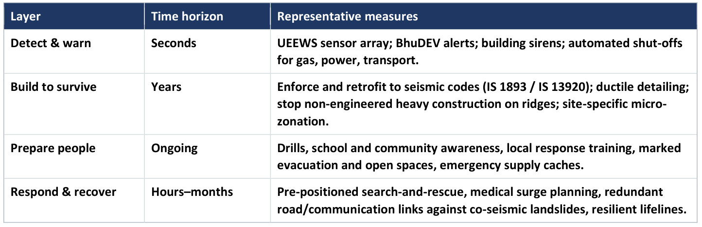
The scientific literature is explicit that scientists cannot stop the earthquake, but they can achieve a better understanding of the mechanisms and share that knowledge with the agencies responsible for preparedness. The search for reliable medium- and short-term precursors continues and is worth pursuing, but no responsible plan depends on it. Structural resilience and preparedness are what convert an unavoidable hazard into a survivable event - early warning is the fast top layer on that foundation, not a substitute for it.
14. Conclusion
The Himalaya represents the major part of a continental collision boundary, and the scientific position is settled: sufficient stress has accumulated along the plate boundary to trigger a great earthquake at any time, and great earthquakes of M≥8 will happen along the Himalayan front. What is not settled, and what no amount of monitoring will settle, is when. Humans will never be capable of preventing the occurrence of the phenomenon itself; the entire policy space lies in what stands above the fault when it moves, and in what the seconds before the shear wave are used for.
For government, the operative question is therefore not “when will the Himalayan earthquake occur?” It is: which interventions reduce expected loss per rupee inside a horizon shorter than the building stock's turnover, and which of those can be legislated, funded and measured this year?
The policy ask
Designate a national earthquake early warning authority; give its alerts statutory status and good-faith immunity; publish an end-to-end latency standard and an automatic seismic actuation standard; mandate cell broadcast as the delivery channel; instrument the Garhwal–Kumaon and Kashmir segments first; and restart the seismic code revision on a staged, consulted and cost-phased pathway. Two hundred crore of capital and thirty crore a year buys the country the seconds it will one day need, and buys them before the code debate concludes.
Selected References
[1] Allen, C. R. (1976). Responsibilities in earthquake prediction. Bulletin of the Seismological Society of America, 66, 2069– 2074.
[2] Bilham, R., Bodin, P., & Jackson, M. (1995). Entertaining a great earthquake in western Nepal. Journal of the Nepal Geological Society, 11, 73–78.
[3] Bilham, R., Gaur, V. K., & Molnar, P. (2001). Himalayan seismic hazard. Science, 293, 1442–1444.
[4] Chandra, U. (1992). Seismotectonics of Himalaya. Current Science, 62, 40–71.
[5] Khattri, K. N. (1987). Great earthquakes, seismicity gaps and potential for earthquake disaster along the Himalaya plate boundary. Tectonophysics, 138, 79–92.
[6] Molnar, P., & Tapponnier, P. (1978). Active tectonics of Tibet. Journal of Geophysical Research, 83, 5361–5375.
[7] Pandey, M. R., Tandukar, R. P., Avouac, J. P., Vergne, J., & Heritier, Th. (1999). Seismotectonics of the Nepal Himalaya. Journal of Asian Earth Sciences, 17, 703–712.
[8] Paudyal, H., & Panthi, A. (2010). Seismic Vulnerability in the Himalayan Region. The Himalayan Physics, 1(1), 14–17.
[9] Paudyal, H., & Singh, H. N. (2008). Seismicity and seismic energy release in the central Himalaya. Journal of Scientific Research, 52, 19–31.
[10] Richter, C. F. (1958). Elementary Seismology. W. H. Freeman & Co., San Francisco.
[11] Upreti, B. N. (2006). Disaster management in Nepal. Policy Paper 27, Economic Policy Network, Ministry of Finance, Government of Nepal.
[12] Wyss, M. (2005). Human losses expected in Himalayan earthquakes. Natural Hazards, 34, 305–314.
[13] Mittal, H., Pal, S., Kumar, R., Saini, A., Wu, Y.-M., Ammani, A., Patel, R. C., Sandeep, & Mishra, O. P. India's Earthquake Early Warning Systems: A Review of Developments and Challenges.
[14] National Centre for Seismology (NCS), Ministry of Earth Sciences (MoES), Government of India — EEW pilot, northwest Himalaya.
[15] Uttarakhand State Disaster Management Authority (USDMA) & IIT Roorkee, Centre of Excellence in Disaster Mitigation and Management — Uttarakhand State Earthquake Early Warning System (UEEWS) and the BhuDEV (Bhukamp Disaster Early Vigilante) app, public launch 4 August 2021.
Useful primary-source links
National Centre for Seismology, Ministry of Earth Sciences
BhuDEV — Uttarakhand Earthquake Early Warning System, IIT Roorkee
PIB — High-risk seismic categorisation of the Himalayan region
Bilham — Himalayan seismic hazard compilation, CIRES
Scientific Reports — rupture variability, central seismic gap (78°–82°E)