Urban Development Planning
Kolkata 2050: Building a Climate-Resilient Coastal City
September 17, 2026

Client: Kolkata Municipal Corporation / KMDA
Engagement: Develop a long-term climate-resilience investment strategy for Kolkata under conditions of limited public resources.
Key Decision: Where should Kolkata prioritise climate-adaptation investment, what interventions should it fund, and how should investment be phased?
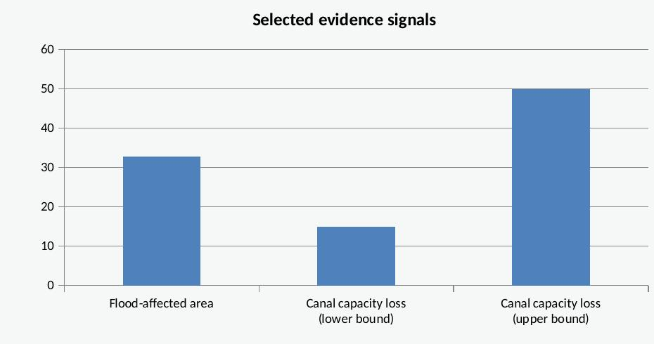
32.75% of Kolkata (65.74 sq km) flood-affected, 2016–2023
63.4% shrinkage of East Kolkata Wetlands, 1991–2023
52.06% of the city now built-up, up from 18.39% in 1990
Executive Summary
Kolkata's future is a story of compounding water risk. Sea-level rise, tidal and coastal flooding, extreme rainfall, land subsidence, and rapid urbanisation are converging on a low-lying deltaic city whose drainage network is, in places, over a century old. Recent events illustrate the stakes directly: in September 2025 Kolkata recorded 251.6 mm of rain in 24 hours, its heaviest since 1988, causing widespread flooding and at least 12 deaths.
This case study proposes a risk-based investment framework rather than a generic infrastructure expansion. It combines hazard, exposure, vulnerability, and existing adaptive capacity into a single residual-risk index, identifies where that risk is highest and least protected, and recommends a phased strategy of Protect and Restore, backed by Regulate and Accommodate. Every intervention is judged not by cost alone, but by risk reduced, people and assets protected, and resilience delivered per rupee crore invested.
Kolkata is not starting from zero: the ADB-backed KSHARP programme (US$200 million loan, roughly Rs 1,700 crore) and two completed KEIIP tranches already represent roughly Rs 5,347 crore of prior investment in drainage and sewerage. The strategic question is therefore not whether to build, but where meaningful risk remains once this pipeline is accounted for and how to close that gap efficiently through to 2050.
2. The Challenge
Kolkata faces a compound set of climate and urban risks that interact rather than operate independently:
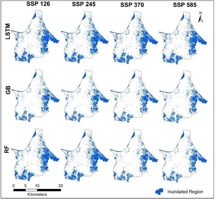
Sea-level rise and coastal flooding: Chakrabortty et al. (2025, Scientific Reports) find Kolkata among the Indian cities facing the highest coastal-flood risk, with extensive inundation projected under the higher emission SSP3-7.0 and SSP5-8.5 scenarios, concentrated along the Hooghly River and coastal lowlands.
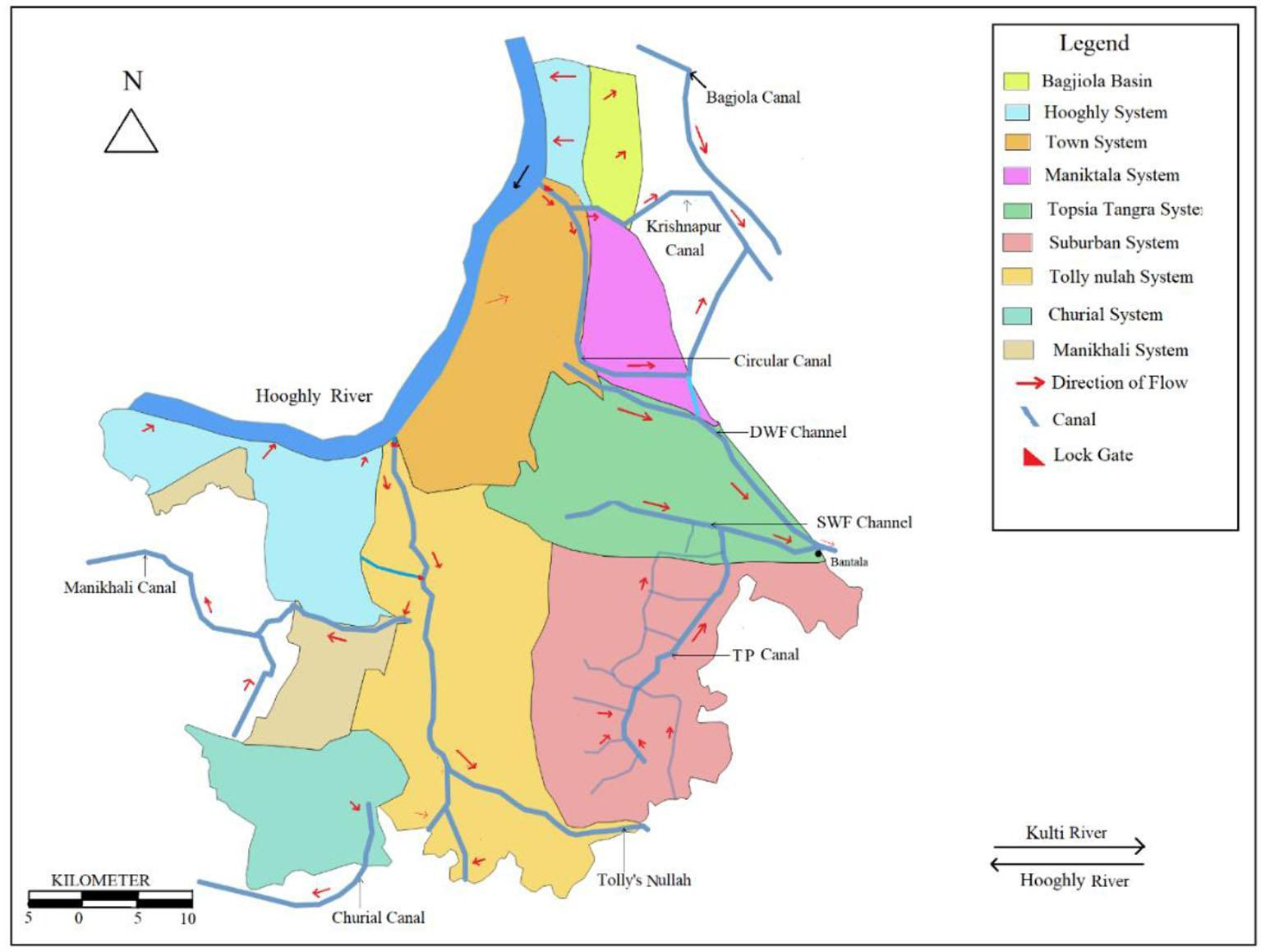
Extreme rainfall and waterlogging: KMC's own Sewerage and Drainage documentation cites heavy siltation, a roughly 180 km network of century-old brick sewers, and pumping stations 50 to 100 years old, originally designed for roughly 6 mm/hour of rainfall, far below current storm intensities.
Cyclones and storm surge: Cyclone Amphan demonstrated how extreme rainfall and storm surge interact with Kolkata's low-lying urban environment; KMC/British Deputy High Commission scenario modelling has tested storm surges of 3 to 5 metres during high tide.
Land subsidence: A 2026 PS-InSAR study of 2017-2023 ground deformation reports mean velocities of approximately -2.8 to -5.5 mm/year, with an expanding subsidence zone linked to groundwater extraction and soft-soil conditions.
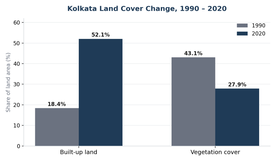
Urbanisation and impervious surfaces: Built-up land across Kolkata and its surroundings rose from 18.39% in 1990 to 52.06% in 2020, while vegetation cover fell from 43.07% to 27.89% over the same period, removing much of the land's natural capacity to absorb rainfall.
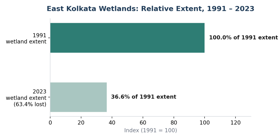
Wetland and water-body loss: A 2026 study finds the East Kolkata Wetlands shrank 63.4% between 1991 and 2023, driven mainly by conversion to agriculture and built-up land, with further decline projected by 2050 under business as usual.
Current-risk evidence
The scale of disruption is already visible, not merely projected. Beyond the September 2025 event, some south Kolkata locations recorded even higher localised rainfall of 332 mm at Garia, 280 mm at Kalighat, 264 mm at Ballygunge, overwhelming drainage and submerging neighbourhoods. In May 2026 the West Bengal government identified over 300 flood/waterlogging "black spots" statewide, including 22 within the KMC area. A September 2026 waterlogging episode caused a road cave-in on the EM Bypass-Alipore corridor, disrupting a major transport artery. A 2026 UN assessment placed Kolkata, Mumbai, and Dhaka among the South Asian cities most exposed to sea-level-driven displacement, noting that global mean sea level rose 5.9 mm in 2024 versus a 4.7 mm annual average over 2014-2023.
Taken together, this is not a single-hazard problem. It is a compound urban-and-coastal flood-risk challenge that will intensify toward 2050, which is why the strategic question is shifting from responding to individual flood events toward deciding, systematically, where to prioritise adaptation investment.
3. The Core Problem and Strategic Questions
Kolkata's future climate risk arises from the interaction of coastal hazards, extreme rainfall, urban exposure, and underlying physical and socioeconomic vulnerability. The task for policymakers is to determine where adaptation investment produces the greatest reduction in risk, not simply where hazard is highest.
Where: Which parts of Kolkata face the greatest combined risk?
Why: What physical, infrastructural, and socioeconomic factors explain this risk?
What: Which interventions are most appropriate for each priority area?
How much: How should limited investment be allocated?
When: Which interventions should happen immediately, and which can be phased?
4. Diagnosing Kolkata's Risk
We propose a Kolkata Climate Risk and Adaptation Index built in GIS, combining four layers: hazard, exposure, vulnerability, and adaptive capacity (existing protection). This goes beyond hazard mapping alone, it asks where risk remains once current and committed protection is taken into account.

Hazard indicators
Extreme rainfall: intensity and frequency of heavy rainfall, measured via max 24-hour rainfall and return-period rainfall.
Tidal flooding: inundation from astronomical tide and river levels, measured via distance/elevation to tidal flood zones.
Storm surge: temporary sea-level rise from storms, measured via modelled surge depth under selected return periods.
Sea-level rise: long-term rise in baseline coastal water level, measured via projected relative sea-level anomaly for 2050/2100.
Cyclone exposure: spatial exposure to cyclone wind, rain and surge, measured via historical cyclone track density.
Elevation: physical propensity for inundation and poor drainage, measured via DEM elevation and relative depression mapping.
Land subsidence: local lowering of ground level raising relative flood depth, measured via recent vertical land-motion rate.
Exposure indicators (illustrative)
Population and density: absolute number of people potentially affected, from WorldPop and Census 2011 ward data.
Built-up area: more impervious land means more exposed physical assets, from Dynamic World/Sentinel-2 and KMDA LUDCP.
Roads and railways: critical for evacuation and emergency response access, from OpenStreetMap and Indian Railways data.
Hospitals and schools: facilities that must remain operational or can shelter people, from ABDM Health Facility Registry and UDISE+.
Power infrastructure: a lifeline whose failure cascades into other systems, from POWERGRID/WBSEDCL/CESC.
Economic assets: industrial, commercial, port and logistics exposure, from KMDA LUDCP and WBIIDC.
Vulnerability and adaptive capacity (illustrative)
Vulnerability layers combine socioeconomic deprivation, informal settlement concentration, age structure, and housing quality with physical/service factors such as drainage-service deficiency, flood recurrence, and accessibility to hospitals and emergency services. Post-Amphan research found strong spatial overlap between flood vulnerability and slum concentration, with Boroughs VII and XV recording particularly high shares of both.
Adaptive capacity captures what is already protecting the city: 8,040 geo-tagged water bodies covering 17.13 million square metres (KMC, 2025-26), the 12,500-hectare East Kolkata Wetlands, and the active KSHARP and prior KEIIP investment pipeline. Canal carrying capacity, however, is reported to have fallen 15 to 50 percent due to siltation, a critical constraint on existing protection.
5. Risk Prioritisation
The four layers are combined into a single baseline risk score, then compared against existing protection to isolate residual risk, the basis for investment prioritisation.
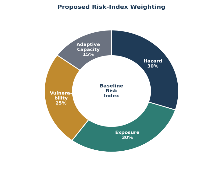
Risk_baseline = 0.30(Hazard) + 0.30(Exposure) + 0.25(Vulnerability) + 0.15(1 minus Adaptive Capacity), each dimension normalised 0 to 1.
Investment Priority = Baseline Risk minus Existing Protection Effectiveness
High risk plus weak existing capacity leads to Priority 1.
High risk plus strong existing capacity, or moderate risk plus a major infrastructure gap, leads to Priority 2.
Low risk plus strong existing capacity leads to Priority 3.
6. Kolkata's Existing Natural Assets: The East Kolkata Wetlands
Area: 12,500 ha Ramsar-designated wetland complex, a large existing ecological asset.
Fisheries: roughly 254 sewage-fed fisheries with fish ponds covering approximately 4,000 ha, an existing productive water-storage landscape.
Wastewater treatment: natural biological/solar treatment via sewage-fed aquaculture, ecological infrastructure performing an urban utility function.
Livelihoods: roughly 20,000 to 25,000 fishing-dependent families protected, per Ramsar records.
Flood management: functions as a retardation basin with documented storage and retention role, a potential complement to drainage and pumping.
Current threats: urbanisation, encroachment, water-body filling, siltation and pollution, meaning existing ecological capacity may be declining.
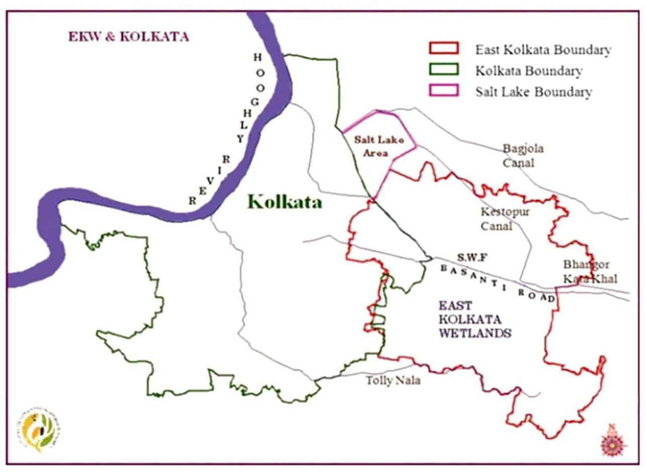
The EKW should be treated not as a substitute for engineered flood infrastructure, but as an existing multi-functional ecological asset whose protection and restoration can reduce residual flood risk while delivering wastewater, livelihood, and food-security co-benefits.
7. Strategic Options
Protect: close the residual infrastructure gap after accounting for KSHARP and other committed projects. Priority targets: drainage bottlenecks, pumping capacity, outfalls/sluices, canal conveyance, and protection of critical roads, hospitals, power infrastructure, and transport nodes.
Restore: recover existing ecological storage and drainage capacity where it overlaps with high residual risk: protect EKW boundaries, restore degraded wetland/water-body areas, desilt and reconnect canals, and introduce blue-green infrastructure in dense urban zones.
Regulate: the cheapest long-term risk-reduction lever. Development is not prohibited, but its flood-risk consequences must be priced and managed through flood-risk-sensitive zoning, restrictions on filling water bodies, minimum flood-storage requirements, and mandatory drainage-impact assessments for major developments.
Accommodate: targeted, not citywide. ADB identifies low-income and informal-settlement areas as facing the most inadequate drainage, with floodwater persisting up to two days in some locations, meaning accommodation measures (raised critical infrastructure, early warning, emergency shelters) should be vulnerability-targeted rather than universal.
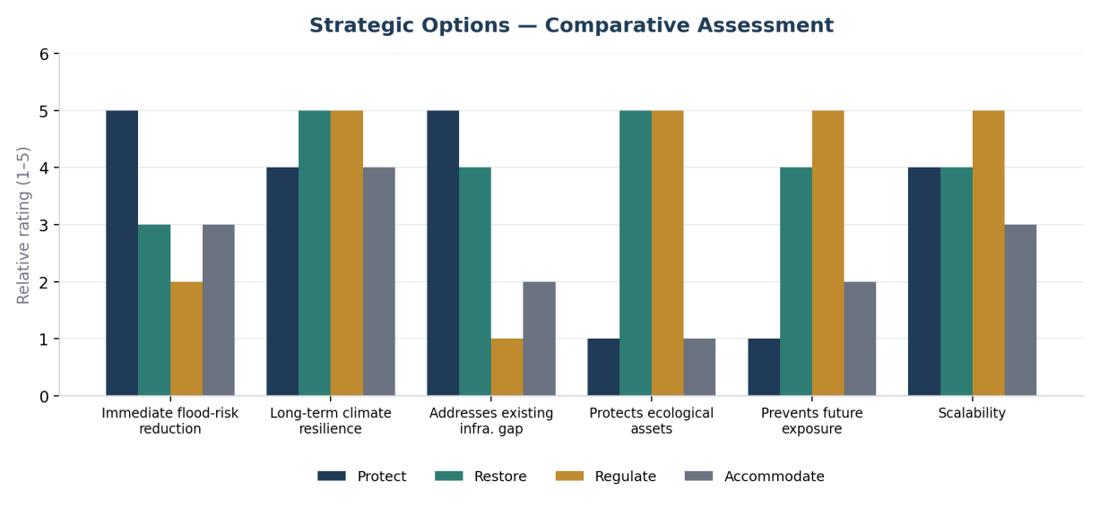
Immediate flood-risk reduction: Protect scores highest, followed by Accommodate and Restore, with Regulate lowest.
Long-term climate resilience: Restore and Regulate score highest, Protect and Accommodate follow.
Addresses existing infrastructure gap: Protect scores highest by a wide margin.
Protects ecological assets: Restore and Regulate score highest, Protect and Accommodate score lowest.
Prevents future exposure: Regulate scores highest, followed by Restore.
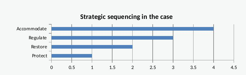
Strategic priority overall: Protect first, then Restore, then Regulate as a cross-cutting measure, then Accommodate.
8. The Investment Decision
Existing government programmes
Kolkata's most important existing investment benchmark is KSHARP, for which ADB approved a US$200 million loan in February 2025 (roughly Rs 1,700 crore) covering 84 km of trunk/secondary sewerage-drainage, 176 km of lateral pipelines, 50,000 household connections, a 41 MLD sewage treatment plant, and five pumping stations. Combined with the two completed KEIIP tranches (roughly US$143 million and US$286 million respectively), total prior ADB-linked investment across phases is approximately US$629 million (roughly Rs 5,347 crore), a scale that should anchor, not be duplicated by, any new investment case.
Indicative intervention cost benchmarks
Rather than generic cost ranges, actual ADB contract values recorded for Kolkata projects are used, converted at roughly Rs 85 per US dollar.
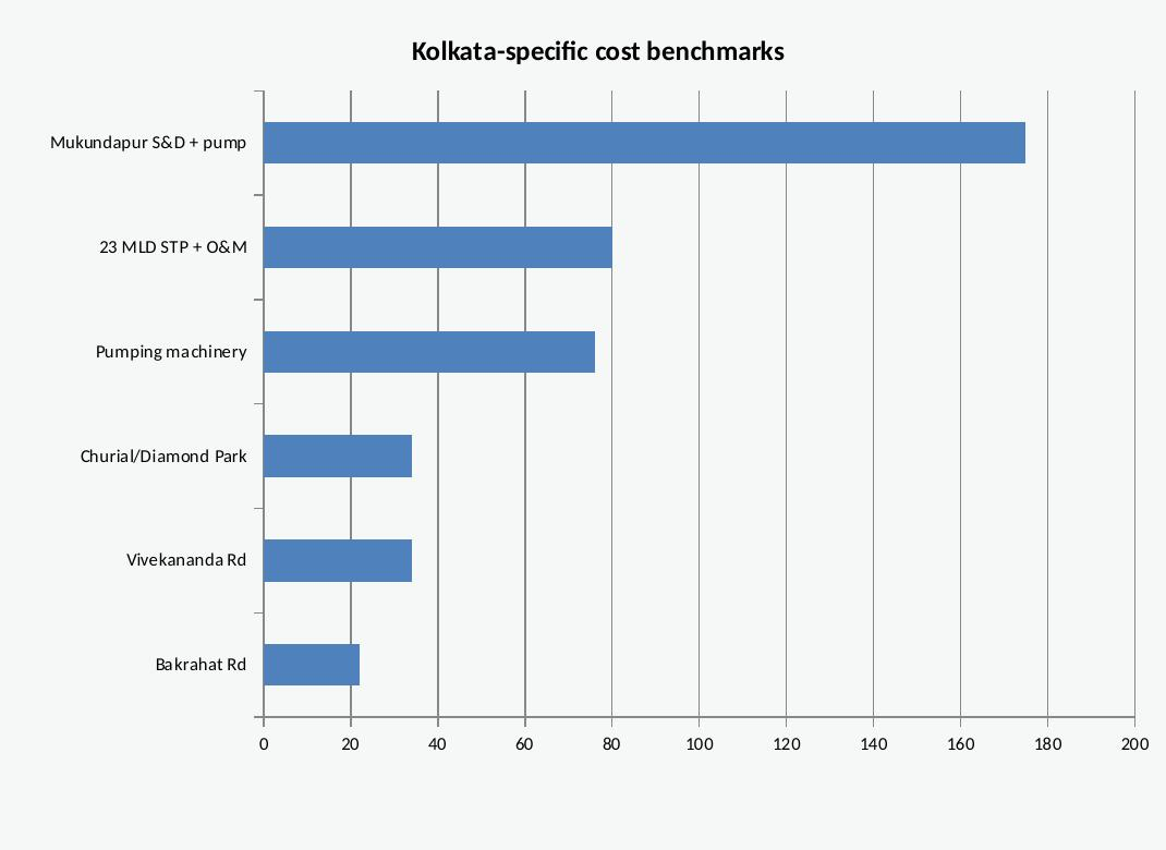
A further Kolkata-specific benchmark: KMC's Rs 207 crore sewerage and drainage project for northern and central Kolkata includes a Rs 175 crore sewer-rehabilitation component expected to benefit over 10 lakh residents across 30 wards, a useful cost-per-beneficiary reference point for comparing candidate interventions.
Available public funding mechanisms
AMRUT 2.0: an indicative national outlay of roughly Rs 2.99 lakh crore (Rs 76,760 crore central share), supporting water-body rejuvenation and urban water security, particularly relevant to Restore interventions.
State and National Disaster Mitigation Funds: Rs 40,880 crore (SDMF) and Rs 79,406 crore (NDMF) allocated under the 16th Finance Commission framework, 2026-27 to 2030-31.
Urban flood mitigation programme (2024): US$300 million announced across seven cities, with Kolkata allocated Rs 500 crore for drainage, water-body enhancement, and early-warning systems.
9. Implementation Roadmap
2026-27, Map and Diagnose: build citywide climate-risk maps, identify flood hotspots and residual-risk zones, map critical infrastructure and vulnerable populations, and identify remaining gaps after existing and planned investment.
2027-29, Prioritise and Pilot: rank zones by residual risk, pilot targeted drainage/pumping upgrades and canal/wetland restoration in the highest-priority area, and establish KPIs of flood depth, duration, drainage capacity, population protected, and investment efficiency.
2029-32, Scale and Integrate: scale interventions with demonstrated risk reduction, expand blue-green infrastructure, integrate climate-risk screening into planning approvals, and strengthen early-warning and emergency-response systems.
2032-2050, Adaptive Management: periodically update risk and vulnerability assessments, monitor rainfall, sea-level, subsidence and land-use change, and reallocate investment as conditions and evidence evolve.
10. Final Recommendation
For Kolkata 2050, the recommendation is a targeted, risk-based Protect and Restore strategy, supported by Regulate and Accommodate measures. Rather than launching another generic citywide drainage programme, Kolkata should first identify residual climate risk after accounting for KSHARP, KEIIP, and ongoing KMC programmes, then direct investment to where high climate risk, vulnerable populations, and critical infrastructure overlap with insufficient existing protection.
Every intervention should be assessed through the same chain: investment, then risk reduction, then beneficiaries, then economic and service value, with priority given, wherever evidence permits, to the interventions delivering the greatest risk reduction per rupee crore invested. This allows Kolkata to move from reactive flood management to evidence-based, phased, and adaptive climate investment through 2050.
The objective for Kolkata should not be to build a bigger drainage system, but to build a city that needs less of one, by capturing water where it falls, restoring the spaces where it once flowed, and revitalising the institutions accountable for the outcome.
References
Chakrabortty, R., Ali, T., Atabay, S., Roy, P., and Pande, C. B. (2025). Impact of climate change scenario on sea level rise and future coastal flooding in major coastal cities of India. Scientific Reports, 15. Mukherjee et al. (2025). Integrated catchment and coastal management for resilient urban flood mitigation under climate change. Frontiers in Water. Cleaner Water (2026). Study on future shrinkage and land-use change of the East Kolkata Wetlands, ScienceDirect. Kolkata Municipal Corporation, Sewerage and Drainage Services, District Environment Plan 2025-26, Budget 2025-26. Asian Development Bank, KSHARP Project (56287-001), KEIIP Tranche 2 (42266-025) and Tranche 3 (42266-026). East Kolkata Wetlands Management Authority (EKWMA), Ramsar Convention wetland records. Reuters, Times of India, Indian Express, 2025-2026 reporting on Kolkata flood events, waterlogging black spots, and drainage programmes.