Urban Development Planning
Great Nicobar: A Nature-Positive, Rights-Respecting Infrastructure Strategy
September 28, 2026

Strategic Risk, Biodiversity and Indigenous-Rights Advisory
1. Executive Summary
The Great Nicobar Island (GNI) project is the most consequential infrastructure bet India has made on a tropical rainforest island since Independence, and it is also the clearest test yet of whether a strategic megaproject can be built without sacrificing an irreplaceable ecosystem or an indigenous people found nowhere else on Earth. Approved by the Union Cabinet in 2021 at an estimated cost of roughly ₹72,000 crore and now tracking closer to ₹81,000–95,000 crore, the project bundles an International Container Transshipment Terminal (ICTT) at Galathea Bay, a greenfield international airport, a township for up to 650,000 people, and a 450 MVA gas-and-solar power plant on an island that is home to two Particularly Vulnerable Tribal Groups (PVTGs), the Shompen and the Nicobarese, and to one of only 36 global biodiversity hotspots.
The National Green Tribunal has twice upheld the project's environmental clearance (2023 and February 2026), while imposing conditions on coral protection, shoreline stability and sandy-beach preservation; litigation continues before the Calcutta High Court on Forest Rights Act compliance, and in May 2026 the UN Committee on the Elimination of Racial Discrimination (CERD) invoked its Early Warning and Urgent Action Procedure over the project's impact on the Shompen. This is not a project where the advisory question is "should it proceed" - that decision has been made at Cabinet level and reaffirmed through two rounds of tribunal review. The live question, and the one on which a strategy, risk and sustainability practice can add durable value, is how 130–166 sq. km of construction can proceed on a seismically active, ecologically singular, tribally inhabited island without becoming India's next stranded asset, its next reputational liability, or the proximate cause of a PVTG's extinction.
This case study sets out that advisory opportunity in five parts: the scope and stakes of the project; four global benchmarks the project can be measured against and retrofitted with - nature-positive port design, precautionary no-go zoning, renewable microgrid townships, and closed-loop water management; and a six-part action framework, illustrative investment logic and engagement roadmap a practice can use to build a client mandate.
2. Project Overview: Scope, Cost and Strategic Rationale
Great Nicobar is the southernmost island of the Andaman and Nicobar archipelago, roughly 40 nautical miles from the Malacca Strait, one of the world's busiest East–West shipping corridors. The government's rationale is explicitly geostrategic: an Indian-flagged trans-shipment hub there would capture container traffic currently transshipped through Colombo, Singapore and Port Klang, and would anchor India's military and civilian presence in the eastern Indian Ocean.

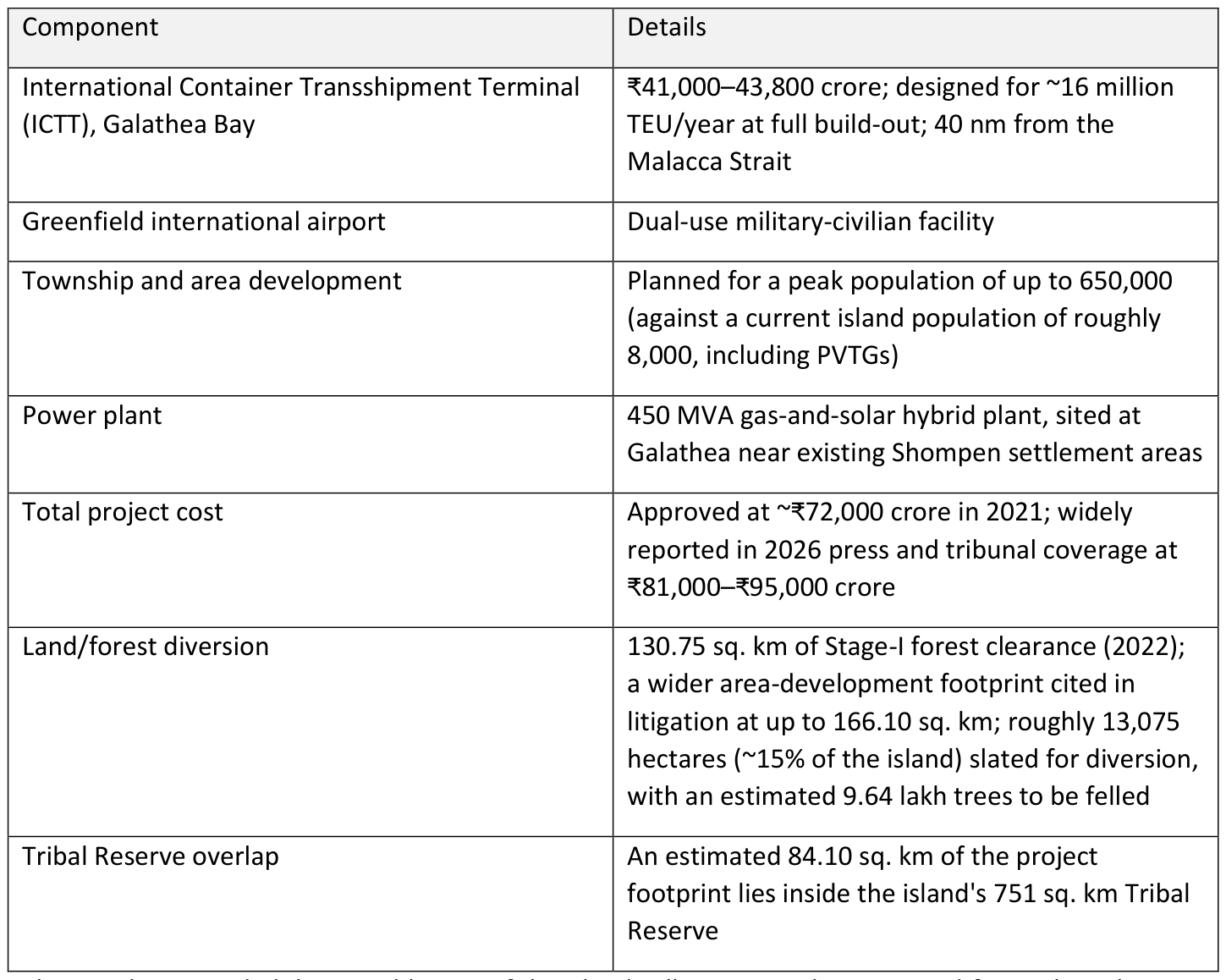
The NGT has recorded that roughly 82% of the island will remain under protected-forest, biosphere-reserve or conservation designation once the project is complete, a figure the project's proponents use to frame the footprint as contained, and which its critics contest on the grounds that the 15–18% under development coincides with the coastal, low-lying, biodiversity-dense and tribally used part of the island, not a representative cross-section of it.
3. The Ecological Stakes: Why Great Nicobar Is Different
Great Nicobar is not a generic coastline. It sits inside the Indo-Burma biodiversity hotspot, carries UNESCO Biosphere Reserve status, and its Galathea and Campbell Bay National Parks anchor one of the last unbroken lowland tropical rainforest-to-reef gradients in South Asia.
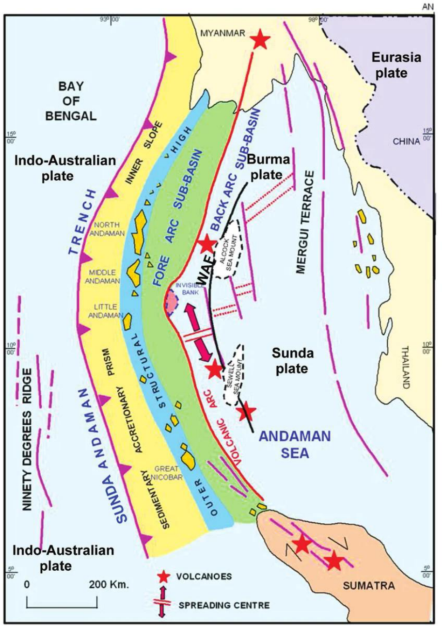
Tectonic map of Andaman and Nicobar Group of Islands and surrounding area showing Arc-Trench Gap area (modified after Curray, 2005).
Coral reefs. The project's environmental clearance requires scientific translocation of an estimated 16,000-plus coral colonies out of the ICTT's construction footprint, among the largest coral-relocation undertakings ever attempted in India, alongside a coral-regeneration and monitoring programme the Environment Ministry must implement under NGT direction.
Keystone and endangered species. The island's Galathea Bay beach is one of the world's most important nesting sites for the giant leatherback turtle; it also hosts the endemic Nicobar megapode, the Nicobar tree shrew, saltwater crocodiles, and the last significant unfragmented habitat of several island-endemic species found nowhere else.
Seismic setting. Great Nicobar sits on the Andaman–Sumatra subduction arc. The 2004 Indian Ocean earthquake (magnitude 9.2) permanently subsided the island's Indira Point by roughly 4.25 meters and killed hundreds of Nicobarese. Experts assessing the project note a quake of that magnitude is unlikely to recur for 400–750 years, but smaller, more frequent seismic and tsunami events remain a live design constraint the National Building Code's earthquake provisions are meant to address.
Carbon and coastal-defence value. The rainforest, mangrove and reef systems slated for partial clearance are simultaneously carbon sinks and the island's only natural storm and tsunami buffer, an ecological service that has direct, quantifiable relevance to the resilience of the ₹81,000-crore asset base being built behind it.
4. The Human Stakes: The Shompen and Nicobarese
Any advisory framework for Great Nicobar that treats the tribal dimension as a compliance footnote will fail, both ethically and commercially; it is now the project's single largest source of international scrutiny.
Who is affected?
The Shompen are a semi-nomadic, hunter-gatherer PVTG numbering an estimated 200–400 people (2011 Census recorded 229; Survival International estimates up to two-thirds remain uncontacted, with little to no immunity to outside infectious disease).
The Nicobarese, the island's larger tribal community (roughly 1,000–1,100 people on Great Nicobar), were themselves displaced once already, resettled off their ancestral lands after the 2004 tsunami destroyed their villages; anthropologists working in the islands have publicly warned the Shompen risk a similar, more permanent displacement.
Both communities live within, and depend on, a 751 sq. km Tribal Reserve, of which roughly 84 sq. km is proposed for denotification.
Consent is contested, not settled. A pending Public Interest Litigation before the Calcutta High Court's Port Blair circuit bench alleges the project's forest clearances proceeded without a valid Forest Rights Act process: no record of a Forest Rights Committee convening a Gram Sabha; the Nicobarese Tribal Council's chairperson-level consent, which the Council itself withdrew in November 2022; and Shompen consent obtained through a government welfare body (AAJVS) rather than the tribe directly, a materially different, and legally weaker, standard than free, prior and informed consent (FPIC). In August 2026, the statutory Tribal Council of Great and Little Nicobar publicly accused the island administration of overlooking its concerns and of pushing the Shompen toward a "modern lifestyle" against their wishes.
International attention. On 5 May 2026, the UN Committee on the Elimination of Racial Discrimination (CERD) formally raised concerns with the Government of India under its Early Warning and Urgent Action Procedure, citing risks to the Shompen's survival, health, traditional territory and resources, and the reported absence of consultation and FPIC. Separately, 39 international scholars and Indigenous-rights experts wrote to President Droupadi Murmu warning that, without safeguards, the project could constitute a form of cultural and physical extinction risk for the Shompen.
The advisory reading. None of this is a reason a practice should decline to engage; it is the reason engagement matters. A credible FPIC process, a genuinely independent Forest Rights Committee, epidemiological protection protocols for uncontacted Shompen sub-groups, and transparent, third-party-monitored resettlement terms for any displaced Nicobarese are not discretionary CSR add-ons; they are the difference between a bankable, litigation-resistant asset and one perpetually exposed to injunction, international sanction risk, and reputational contagion for every contractor, lender and offtake partner attached to it.
5. Regulatory and Legal Status
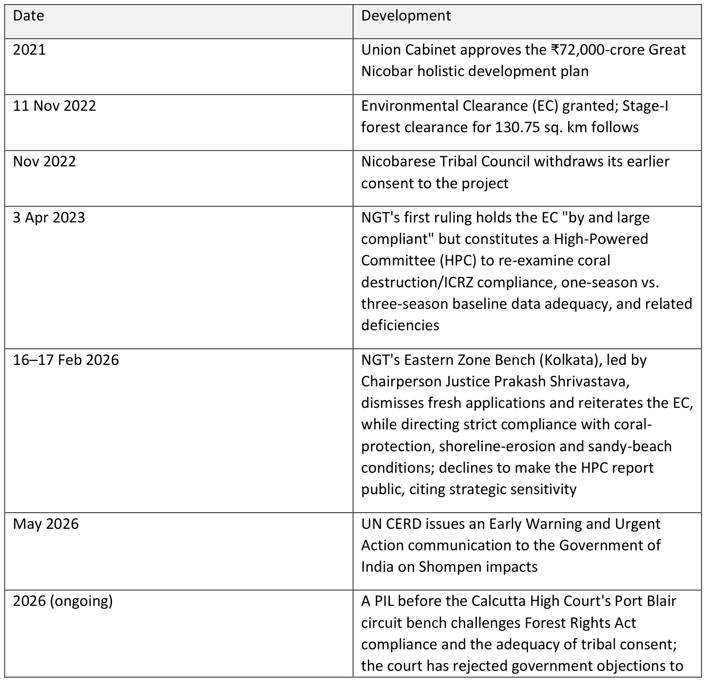
The practical reading for a client or lender: the project's environmental and forest clearances have survived two rounds of tribunal scrutiny, which de-risks it from an outright injunction, but the NGT's own conditions- coral translocation and regeneration, no loss of sandy beaches, no adverse shoreline change, and full compliance monitoring- are legally binding, not aspirational, and non-compliance on any one of them is the most probable route to a future stay order. The unresolved Forest Rights Act litigation is the second major residual risk: because it turns on process (was FPIC obtained correctly), not on the underlying environmental science, it cannot be closed by better engineering, only by a credible, re-run consent process.
6. Global Benchmark 1 - Nature-Positive Infrastructure: The Port of Rotterdam
Europe's largest port offers the clearest template for what "nature-positive" means in practice for a working port, not just in a mission statement. In September 2025 the Port of Rotterdam Authority adopted a Nature Vision (2025–2050), developed with the Naturalis Biodiversity Center, built on three pillars: creating physical room for nature within an operating industrial port, reducing pressure factors (light, noise, waste, water and soil quality), and embedding biodiversity into corporate and project decision-making. The port has mapped nine distinct landscapes across its 25 km of land and 60 km of sea frontage - dune, tidal, coastal and estuarine - each with its own restoration commitments, and set a public target of a 5% biodiversity increase within the port area between 2022 and 2027.
Critically, this is not confined to the port's edges. The Maasvlakte Zuid railway yard, a live freight-infrastructure project, is being built with nature-inclusive design as standard: nature-friendly banks, dune vegetation, amphibian ponds and breeding pontoons for vulnerable coastal birds integrated into the yard layout itself, not bolted on afterwards. Comparable models exist elsewhere: the Port of Antwerp's Ecological Infrastructure programme manages 90-plus protected species across 650,000 sq. m of green corridors connecting spawning and habitat zones inside one of Europe's largest industrial ports, and Brazil's Porto do Açu has turned the 4,000-hectare Caruara Reserve, half of its operational land, into an active ecological and social restoration zone.
Application to Galathea Bay. The ICTT's terminal, breakwater and dredging footprint is the single highest-leverage point for a nature-positive retrofit, because unlike the tribal-consent question it is primarily an engineering and design choice, not a legal one. A practice can propose: (i) a published, Nicobar-specific Nature Vision co-developed with an Indian marine-biology institution (e.g., ZSI or a CMFRI-equivalent), naming distinct landscapes such as reef, mangrove, sandy beach, rainforest edge, with measurable, time-bound restoration commitments, mirroring Rotterdam's structure; (ii) engineering the coral-translocation program the NGT has already mandated as a living reef-restoration asset (artificial reef modules, monitored recovery rates, publicly reported survival data) rather than a one-time compliance exercise; and (iii) designing port ancillary infrastructure, such as access roads, workers' camps, breakwaters, with the same nature-inclusive-by-default standard Rotterdam applies to Maasvlakte Zuid, rather than treating ecological features as an afterthought to be added once the concrete is poured.
7. Global Benchmark 2 No-Go Zones and Precautionary Zoning
Pulau Ubin / Chek Jawa, Singapore. In 1992, Singapore's Urban Redevelopment Authority approved land reclamation across Chek Jawa, a 100-hectare cape on Pulau Ubin where six ecosystems: sandy beach, rocky shore, seagrass lagoon, coral rubble, mangrove and coastal forest, converge in one place. When the plans became public in 2001, a volunteer-led biodiversity survey documented the site's ecological richness; public appeals followed, and the government deferred reclamation indefinitely "for as long as Pulau Ubin is not required for development." By 2013, the island was formally removed from Singapore's master plan altogether. Today Chek Jawa is a permanent no-go zone for development, managed instead with a boardwalk, a viewing tower and a visitor cap that lets the public experience the site without touching its core habitats, proof that a no-go designation and public access are not mutually exclusive.
Barrow Island, Australia. A more directly relevant precedent for Great Nicobar is Barrow Island, a Class A Nature Reserve off Western Australia, the country's highest protection tier, that has hosted both Australia's largest onshore oilfield and, since 2009, Chevron's US$54 billion Gorgon LNG project, one of the largest resource developments in the country's history. The state approved Gorgon on the explicit condition that construction be confined to 332 hectares (1.4% of the island) and that a rigorous Quarantine Management System (QMS) prevent any non-native species from establishing on an island that supports 24 species found nowhere else. Over six years of construction, more than 500,000 passenger movements and 12.2 million tonnes of freight passed through the QMS's inspection regime; extensive post-construction surveillance has not detected a single established non-indigenous species. The Australian government has recognised the QMS with a national biosecurity award, and it is now studied globally as a model for how an industrial megaproject can be spatially and biosecurity-fenced away from a high-conservation-value reserve it sits inside.
Application to Great Nicobar. The island's 82%-remains-protected framing is a start, but it is a coarse, whole-island statistic, not a spatial no-go map. A practice can propose a Nicobar-specific no-go and buffer-zone architecture with three tiers, modelled on both precedents: (i) hard no-go zones : Galathea Bay's leatherback nesting beach, core Shompen settlement and foraging areas identified through community mapping (not government proxy consent), and named coral and mangrove patches, fixed by law, not by administrative discretion, the way Chek Jawa was removed from Singapore's master plan rather than merely "paused"; (ii) buffer zones with monitored access, extending the logic of the NGT's contested buffer reductions around Galathea and Campbell Bay National Parks back outward rather than inward; and (iii) an island-wide Quarantine and Biosecurity Management System, styled on Barrow Island's QMS, screening the estimated hundreds of thousands of construction workers, vessels and freight movements the township and port will bring, since invasive species (rats, cats, house geckos) are as existential a threat to Nicobar's endemic reptiles and birds as habitat loss itself and are presently unaddressed in the public clearance conditions.
8. Global Benchmark 3 Renewable Energy Microgrid Townships
Samsø, Denmark. In 1997, this 114 sq. km island of roughly 3,700–4,300 residents, then entirely dependent on imported coal and oil, won a Danish government competition to prove a defined community could convert to 100% renewable energy within ten years, without major state subsidy. It did so: 11 onshore and 10 offshore wind turbines (80% locally financed and locally owned, largely by farmers and residents), four biomass district-heating plants, and rooftop solar took Samsø to net-positive renewable electricity by 2007, cut per-capita emissions from 11 tonnes of CO₂ to 4.4 tonnes, and turned islanders from energy consumers into energy exporters and, through the Samsø Energy Academy (est. 2007), into paid consultants to other communities worldwide. The island's SMILE smart-grid pilot at Ballen Harbour continues to test EV charging and smart-grid balancing, and Samsø is targeting a fully fossil-free island (including transport and heating) by 2030.
The broader island-microgrid pattern. Samsø is one of a now-established class of solutions, remote and island microgrids pairing wind or solar generation with battery storage and local ownership to displace diesel or coal (comparable models include King Island, Tasmania and Ta'u, American Samoa), that share three design features directly transferable to Nicobar: local ownership or revenue-sharing to build community buy-in; a phased build (proof-of-concept scale before island-wide roll-out); and public, real-time generation-consumption data that turns the grid into a visible civic asset rather than a utility black box.
Application to Great Nicobar. The current plan for a 450 MVA gas-and-solar hybrid power plant sited near Galathea, adjacent to Shompen settlement areas, is the single most consequential unresolved design choice in the whole project, on both emissions and tribal-proximity grounds. A practice's advisory case: reweight the mix toward solar, wind (the island has strong, consistent trade-wind exposure) and battery storage with gas retained only as backup/peaking capacity, not baseload; relocate primary generation and transmission infrastructure away from the Tribal Reserve boundary entirely; and structure the township's own build-out as a series of distributed microgrids by precinct (port operations, airport, residential township) rather than one centralized plant; both reducing single-point failure risk on a seismically active island and creating the kind of phased, monitorable rollout Samsø used to build local legitimacy before scaling.
A Nicobar Energy Transition programme, modelled explicitly on the Samsø Energy Academy, could also convert the island's clean-energy build into a demonstrable ESG and PR asset for GNI's operators, addressing reputational risk, not just electrons.
9. Global Benchmark 4 Water Management: Rottnest Island
Rottnest Island, 19 km off Western Australia, is a 1,900-hectare tourist island with no fresh surface water and, like Great Nicobar, a thin freshwater lens sitting over saline groundwater, an inherently fragile hydrology shared by most small tropical and temperate islands. Rottnest historically drew on that freshwater lens directly, but declining winter rainfall (down roughly 20% since the 1960s) made continued groundwater abstraction unsustainable: modelling shows every reduction in rainfall thins the freshwater lens, lowers discharge, and raises salinity in the seeps that native flora and fauna depend on.
The Rottnest Island Authority's response, since 2017, has been to stop groundwater abstraction entirely and self-generate all the island's water needs from a reverse-osmosis desalination plant at Longreach Bay (pumping saline water from beach bores, pressurising it to 6,000 kPa) producing up to 500,000 litres per day, while a separate membrane-bioreactor wastewater treatment plant recycles treated effluent for irrigation on the island's golf course and public greens. The freshwater aquifer itself is now deliberately left untouched, reserved for the island's native ecosystem rather than shared with human consumption; an explicit, engineered separation between human water security and ecological water security on the same small island.
Application to Great Nicobar. A township for up to 650,000 people plus a working port and airport will place immense pressure on an island ecosystem with no large perennial rivers and a hydrology likely at least as fragile as Rottnest's, compounded by tropical rainfall variability and the same seismic/tsunami exposure that can contaminate coastal aquifers with saltwater intrusion in a single event. The advisory recommendation: commission an independent island-wide groundwater and freshwater-lens study before township water infrastructure is finalized (the kind of hydrogeological baseline Rottnest built with its national science agency, ANSTO); size desalination and wastewater-recycling capacity to fully serve the township and port from day one, explicitly ring-fencing any natural aquifer or forest catchment for ecosystem and tribal community use only; and mandate closed-loop water reuse (treated wastewater for landscaping, non-potable port operations and firefighting) as a design standard from the first construction phase, not a retrofit, both reducing long-run opex and removing water stress as a future flashpoint between the township, the port and the Shompen and Nicobarese communities who depend on the same forest catchments for drinking water, a concern the pending Forest Rights Act litigation explicitly raises.
10. Where Is the Risk Highest? A Site-and-Stakeholder Prioritisation View
Not every element of GNI carries the same risk profile. Prioritising advisory and safeguard investment requires weighing ecological sensitivity, tribal proximity, legal exposure and reversibility together, rather than treating the project as a single undifferentiated "green vs. development" question.
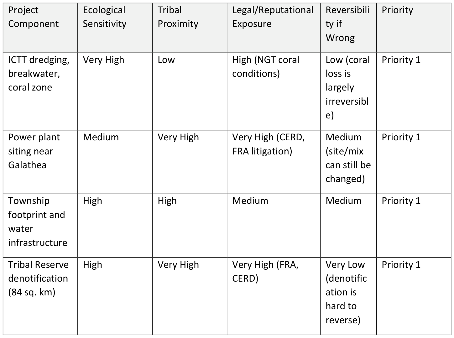
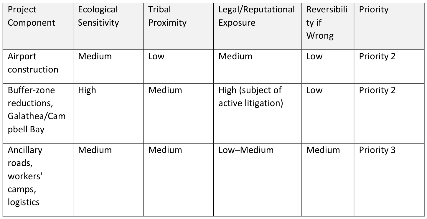
The pattern is clear: the highest-priority risks are concentrated where ecological irreversibility (coral, old-growth rainforest, a 400–750-year-return seismic hazard) meets human irreversibility (a PVTG's territory and, in the Shompen's case, potentially its survival as a distinct people); not where the capital expenditure is the largest. A safeguard programme that spends heavily on generic environmental-management infrastructure while under-resourcing tribal consent and coral protection is optimising for the wrong variable.
11. A Six-Part Advisory Framework for Great Nicobar
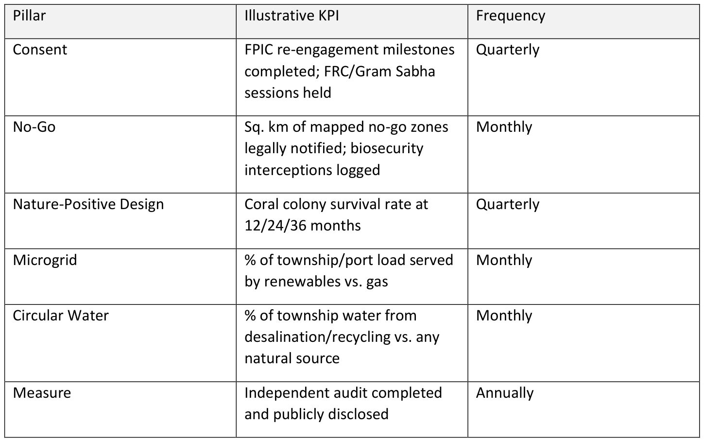
CONSENT. Commission an independent, FPIC-standard re-engagement with the Shompen and Nicobarese, conducted by anthropologists and interpreters, not the island administration, to remedy the process gaps identified in the pending Forest Rights Act litigation before they harden into a permanent legal liability; convene the statutory Forest Rights Committee the petition alleges never met.
NO-GO. Translate the NGT's coastal and habitat conditions into a legally fixed, publicly mapped no-go and buffer-zone architecture, Galathea's nesting beach, Shompen settlement and foraging territory, named coral and mangrove patches; styled on Chek Jawa's permanent deferment, paired with a Barrow-Island-style Quarantine and Biosecurity Management System for all construction workers, vessels and freight.
NATURE-POSITIVE DESIGN. Publish a Nicobar Nature Vision with an Indian marine and forest research partner, naming distinct landscapes (reef, mangrove, beach, rainforest edge) with measurable restoration targets, and make nature-inclusive design the default standard for port ancillary works, not an afterthought; following Rotterdam's Maasvlakte Zuid model.
MICROGRID. Rebalance the 450 MVA power plan toward solar, wind and storage with gas as backup only; relocate generation and transmission away from the Tribal Reserve boundary; phase the build as distributed precinct microgrids rather than one centralised plant, reducing single-point failure risk on a seismically active island.
CIRCULAR WATER. Commission an independent freshwater-lens and groundwater study before finalising township water infrastructure; size desalination and wastewater-recycling capacity to serve the township and port entirely from non-forest sources; ring-fence forest catchments for ecosystem and tribal use only.
MEASURE. Stand up an independent, third-party-audited monitoring and disclosure regime; coral-colony survival rates, Shompen-territory encroachment incidents, groundwater-lens thickness, renewable-generation share, biosecurity interceptions; published on a public dashboard, converting the NGT's compliance conditions from a one-time clearance exercise into an ongoing, verifiable performance record that can withstand future litigation, CERD follow-up, and lender due diligence.
12. The Business Case: Illustrative Risk-Adjusted Logic
As with any megaproject safeguard programme, there is no single validated ₹ figure for "the cost of getting Great Nicobar wrong." The number that matters to a client: the government, a contractor, a lender or an insurer, is the delta between the cost of proactive safeguards and the cost of a stop-work order, an international sanctions or divestment campaign, or an irreversible ecological or human loss. The worked example below is illustrative only, built to show the calculation logic a diagnostic engagement would replace with project-specific figures.
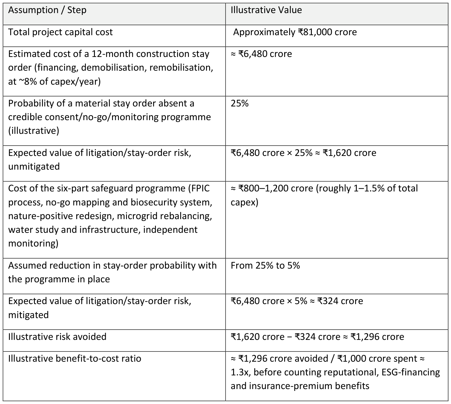
The logic — capital at risk → probability of disruption → expected loss → cost of mitigation → risk avoided → return - is the deliverable a practice sells, not these specific numbers; an actual mandate would replace every assumption here with project financing terms, insurer loss data, and a legal probability assessment specific to the pending Calcutta High Court and CERD processes.
13. Illustrative Client Engagement Roadmap
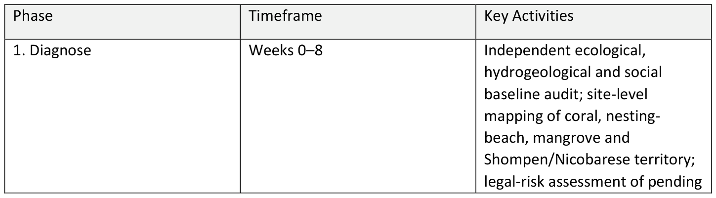
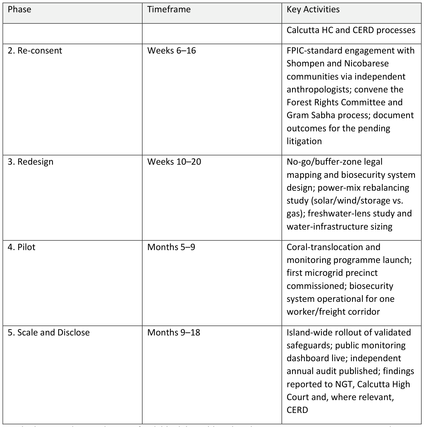
Each phase produces a discrete, fundable deliverable: a baseline report, a re-run consent record, a redesign specification, a working pilot, a disclosed audit; so that a client (ministry, port operator, lender or insurer) can commission the engagement in stages rather than committing to the full programme up front.
14. Key Takeaways and Conclusion
1. The decision to build has been made; the decision on how has not. Two NGT rulings have upheld the clearance; the live questions are design, consent process and monitoring, not project cancellation.
2. Ecological and human risk are concentrated in the same places. Galathea Bay's coral and nesting beach, and the Tribal Reserve boundary, are simultaneously the highest ecological-sensitivity and highest tribal-proximity zones. Therefore, safeguard investment should follow that overlap, not the capex map.
3. Consent is now an international-law exposure, not just a domestic one. The May 2026 CERD communication changes the risk category from litigation to reputational and diplomatic exposure for every entity financing or contracting on the project.
4. Four working global precedents already answer the "how." Rotterdam shows nature-positive port design at scale; Pulau Ubin and Barrow Island show that legally fixed no-go zones and industrial development can coexist on the same small area; Samsø shows a renewable microgrid can be built with local legitimacy in under a decade; Rottnest shows how a small island separates human water security from ecological water security.
5. The 450 MVA gas-and-solar plant siting is the single highest-leverage redesign decision available today, because it is still a design choice, not yet a legal fact.
6. Measurement converts compliance into a defensible asset. A published, independently audited monitoring regime is the cheapest form of litigation and reputational insurance available to the project.
The advisory ask.
For a strategy, risk and ESG practice, Great Nicobar is not a project to have an opinion on; rather, it is a project to help build correctly. The client question is not "is this development justified," but "where exactly is irreversible value- ecological, cultural, financial- at risk, and which of the four proven global models closes that gap fastest, most credibly, and most durably against the litigation and international scrutiny the project already faces."
Selected Sources
1. NGT Approves Great Nicobar Project — Drishti IAS
2. NGT Clears Great Nicobar Infra Project — ETV Bharat
3. NGT Dismisses Fresh Pleas on Great Nicobar Project — Nicobar Times
4. Great Nicobar Project Faces Forest Rights Challenge — Vajiram & Ravi
5. UN CERD Raises Concerns on Shompen Tribe — Change.org petition update
6. Great Nicobar Project overview — Vajiram & Ravi
7. Tribal Council Says Concerns Overlooked — Superkalam
8. Great Nicobar Tribe Faces "Genocide" Warning — India Sea Trade News
9. Port of Rotterdam Authority Nature Vision 2025–2050 (PDF)
10. Port of Rotterdam Unveils Nature-Inclusive Vision — Port Technology
11. Nature and People Positive Ports — World Economic Forum
12. Chek Jawa Wetlands — NParks
13. Saving Chek Jawa — National Heritage Board Roots
14. Gorgon Project and Barrow Island Quarantine — Chevron Australia
15. Barrow Island Quarantine: Beyond Best Practice — Chevron (PDF)
16. Barrow Island's Gorgon Gas Project — Invasive Species Council
17. Samsø: An Island Community Pointing to the Future — UNFCCC
18. Samsø, Denmark — 100% Renewable Islands Network
19. Hydrating the Island — Rottnest Island Authority
As-of date: 26 September 2026. Figures for the Great Nicobar project are drawn from public tribunal orders, government statements and contemporaneous reporting; costs and forest-diversion figures vary across sources (₹72,000–₹95,000 crore; 130.75–166.10 sq. km) and should be confirmed against the current environmental clearance and forest clearance documents before use in a client-facing deliverable. Financial illustrations in Section 12 are hypothetical and marked as such.